American Planning Association 2013 Conference: Sustainable Street Network
Joseph Readdy of Schemata Workshop was invited to participate in a panel at the 2013 American Planning Association national planning conference – Plan Big Chicago. Our panel was devoted to the principles of a sustainable street network. The panel was organized and moderated by Heather Smith, planning director for the Congress for the New Urbanism. The other panel members included Jacky Grimshaw, vice president of the Center for Neighborhood Technology and Marcy McInelly, principal at Urbsworks, Inc. The topic of our panel was to challenge planners to reevaluate their transportation plans and policies and rethink their approach to the design of their streets in their communities. This is my presentation:
A Hypothesis and a Call to Action
I enjoy logic problems. I’ll often start my morning finishing my coffee and solving the Sudoku puzzle in The Oregonian or the crossword in The New York Times. But logic problems like those are not adequate preparation for urban design or transportation planning. Logic problems like ken-ken, sudoku, or the crossword puzzle are considered “tame,” while urban design problems exhibit all of the characteristics of a “wicked problem.”

the Saturday puzzle
"Wicked problem" is a phrase coined originally by two professors from UC Berkeley for use in social planning to describe any problem that is difficult or impossible to solve because of incomplete, contradictory, and changing determinants that are often difficult to recognize or not immediately apparent. The term ‘wicked’ is used, not in the sense of evil but rather its resistance to resolution. Professors Horst Rittel and Melvin M. Webber developed the concept of wicked problems in a 1973 treatise, contrasting "wicked" problems with relatively "tame," soluble problems in mathematics, chess, or puzzle solving. Their formulation of wicked problems in social policy planning specified ten characteristics. In the graduate seminar that I developed and teach at Portland State University, I’ve developed four principles for the wicked problem that helps describe their role in urban design and transportation:
1. each wicked problem is not fully understood until after the formulation of a solution;
2. stakeholders may have radically different world views and vastly different frames of reference for understanding the wicked problem, so a solution to some stakeholders is not a solution for other stakeholders;
3. constraints and resources to solve a wicked problem will change over the course of formulating a solution; and
4. the problem is never solved.
In my experience, each of these principles feels true and captures a fundamental challenge of urban design problems. Of the four, the last makes the point that many in the design profession fail to perceive to the detriment of our cities and the social, cultural, and economic exchange that they are meant to foster and support. Early modern architects applied their knowledge, experience, and skills to the environmental degradation and squalor of the early 20th century city, especially those issues of extreme poverty and social housing. I am convinced that because the solutions that they envisioned were intended to eradicate for all time these problems, their belief in a perfect solution that would endure for all time was a fundamental and fatal flaw, as was their goal of an international –or placeless and timeless– approach to design.

Ville Radieuse applied to the city of Algiers Photo : Lucien Hervé © FLC/ADAGP

Le Corbusier, Plan Voisin, Paris, 1925. Drawing: Stuart E. Cohen and Steven W. Hurtt. Fig. 2-6 in: TRANCIK, Roger (1986). Finding Lost Space. Theories of Urban Design. Van Nostrand Reinhold Company, New York.
“Some problems are so complex that you have to be highly intelligent and well informed just to be undecided about them.”
Strategies to tackle wicked problems
Wicked problems defy a traditional approach to problem solving in which problems are defined, analyzed, and overcome in discrete, sequential, and logical steps because there is never a clear, concise, and complete definition of a wicked problem. There are three strategies to cope with wicked problems:
Authoritative
These strategies seek to tame wicked problems by vesting the responsibility for solving the problems in the hands of a few people. The reduction in the number of stakeholders reduces problem complexity, as many competing points of view are eliminated at the start. The disadvantage is that authorities and experts charged with solving the problem may not have an appreciation of all the perspectives needed to tackle the problem.
Competitive
These strategies attempt to solve wicked problems by pitting opposing points of view against each other, requiring parties that hold these views to come up with their preferred solutions. The advantage of this approach is that different solutions can be weighed up against each other and the best one chosen. The disadvantage is that this adversarial approach creates a confrontational environment in which knowledge sharing is discouraged. Consequently, the parties involved may not have an incentive to come up with their best possible solution.
Collaborative
These strategies aim to engage all stakeholders to find the best possible solution for all. Typically these approaches involve meetings in which all parties have equal standing and all issues and ideas are discussed and thoroughly understood before a common approach is formulated for implementation. I believe that only a collaborative approach truly offers the best opportunities for successful engagement of urban design problems.
In a 1972 paper, Rittel hints at a collaborative approach; one which attempts, "…to make those people who are being affected into participants of the planning process . They are not merely asked but actively involved in the planning process…" In her 2000 paper, Nancy C. Roberts, Professor in the School of Information Sciences at the Naval Postgraduate School in Monterey, California, says of solutions to wicked problems, “We learn to take care in attempting to tame wicked problems by turning them over to experts or some center of power for definition and solution. If we are truly dealing with wicked problems when no one is “in control,” then it is unlikely that the experts and leaders will be able to act unilaterally to define the problems and their solutions. In fact, their insistence in doing so may impede the problem solving process. We learn that wicked problems are socially defined so that getting the “whole system in the room” to enable people to learn from one another is very useful.” In other words, a collaborative and inclusive approach will yield better, more intelligent, more robust solutions to our wicked problems.
Hypothesis:
If the fundamental purpose of cities is to maximize social, cultural, and economic exchange, then we must change the way that we design our streets. We’ve been defaulting to the authoritative approach for the design of our streets for too long. We’ve been giving the design of these important parts of our public realm to our “experts” who apply their knowledge, tools, and training to their design at the expense of place. The tools that we are currently using to illustrate street design results in a street network that:
- prioritizes the free flow of automobiles;
- is resource intensive or wasteful – both initially and long-term;
- contributes to our sedentary lifestyle and the chronic diseases that arise from it;
- unfairly burdens both the young, the old, the poor and people of color; and
- diminishes the social, cultural, and economic exchange that we seek.
Streets in our cities serve two essential functions: to connect people to destinations and to be places in and of themselves. When we design to connect people to these destinations, we seem to plan for destinations that are too far apart to make effective use of walking, biking, or transit as alternatives to the automobile. Yet, more than half of all trips in the United States are three miles or less; forty percent of all trips are two miles or less; and nearly thirty percent of all trips are one mile or less. Yet we design our streets as if every trip was a marathon and every second of delay counts significantly. Melvin Webber, one of the authors of the wicked problem, in the 1960’s decried the “non-place urban realm” which he felt was used to legitimize the domination of the automobile over public transportation and the pedestrian.
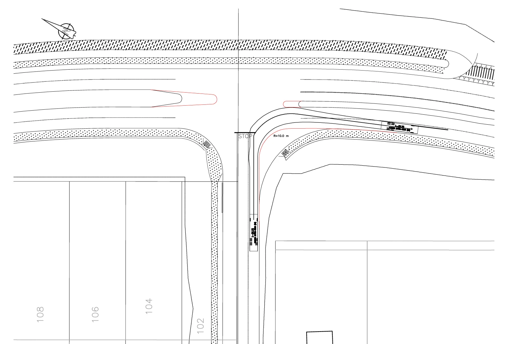
An expert solves the problem of the turning radius of a transit bus at an urban street intersection at the expense of economic development and other modes of travel. The red lines indicate the location of the curbs as initially designed by the urban design team. The new curbs (in black) represent the engineers proposed solution.
One of the reasons we prioritize the free flow of automobiles is the way that we choose to illustrate the solutions to street design problems. When we design to a “functional classification” or for “level of service” we eliminate consideration for the placemaking qualities of the street. Illustrations like this one are often used to show how the curb radii need to be eased and the landscape medians need to be reduced in extent, and sight lines need to be created at street corners to accommodate the safe travel movements of tractor-trailer freight delivery or public transport. What illustrations like this fail to show is the negative impacts:
- on-street parking is lost that could serve neighborhood retailers;
- development potential and property tax income is lost to required sight lines;
- speeds increase;
- bicycle safety is diminished and biking is discouraged; and
- pedestrian safety is compromised and walking is discouraged.
In February I attended and helped facilitate a training in the Institute of Transportation Engineers (ITE) in Chicago. Most of the participants were experienced engineers that work for Illinois Department of Transportation. All the participants were interested in learning how to apply the new guidelines from the 2010 ITE Manual for Creating Walkable Urban Thoroughfares. One of the case studies was a downtown street in a small city that had been laid out in the 19th Century. Eventually the street under study became one of a pair of the State highway that passed through town. Despite their extensive experience and knowledge, the members of the training class developed solutions for this main street that ignored the role of all other streets in the network. They had trouble remembering that there were other streets that could support the function of the network and that this particular street did not have to provide every function: freight mobility, on-street parking, left-turn access to mid-block surface parking lots, bicycle lanes, and expanded sidewalks. One of the reasons it was possible to ignore the additional capacity that the network does provide was the base maps provided in the training showed only the one street rather than showing a larger context.
“The best transportation plan is a land use plan,” Brent Toderian. “The best land use plan is a transportation plan,” Ian Lockwood. The figure-ground relationship that is the network of streets and fabric of blocks that make up our cities means that both Toderian and Lockwood are kind of wrong in the sense that neither can predominate the other. You can’t have a land use plan without a transportation plan and should that transportation plan ignore its context and fail to adequately support the adjacent land uses it will also fail the society that it is intended to serve. Other than taxi and bus drivers, no one makes money going places. You may save money by saving time when you go places, but wealth is created only in that fabric between the streets where people meet.
The disadvantage of the authoritative approach to solving wicked problems is evident in the sample illustration above. A well-educated, highly-skilled, and licensed engineer’s response to the urban design of an intersection is to discount the needs of pedestrians and bicyclists and ignore the economic potential of land uses while making the turning movements for large vehicles easy, convenient, and safe. The expert is never charged with applying a collaborative approach with the residents, neighbors, and businesses that would accommodate and support other modes of transport. The expert accepts no responsibility for the loss of value or economic development potential for the adjacent land use. These elements have been abstracted out of the problem set, so the solution under the authoritative approach is obvious to the individuals who control the technology and are secure in their expertise.
Challenging solutions like this intersection all too often places other interested parties into the competitive approach to solving wicked problems where the various parties attack one another using their respective set of “experts” to defend their entrenched positions. Eventually a solution that satisfies no one emerges, but most often it is the solution most strongly influenced by whichever expert is in control of the technology that developed and represents the solution.

A spread from the CNU Project for Transportation Reform Sustainable Street Network Principles.
© 2012The Congress for the New Urbanism.
A Call to Action
Employ a collaborative approach to the identification, redefinition, and solution of the design of the streets in your community. Create a street network that supports communities and places by including and empowering the residents, neighbors, and businesses. Make them equal members of the larger design team. Use them to map the existing network that is their community. Help them identify those qualities that represent the existing strengths of the community, the opportunities for repair and renewal, and the border vacuums that unnecessarily isolate elements of their community and interrupt the network. Work together to illustrate how well the layout of the network influences the social, cultural, economic, and environmental performance of the places in their lives. Give the community access to, and control of, appropriate technology that enables them to communicate their full understanding of the needs of the community.
Model the network first. For much of our recent history we’ve employed those things that have been easy to measure such as, average daily volume of automobile traffic or the level of service of an intersection, as the essential determinants that must be solved in street design. We’ve invested those things that we can easily measure with importance that far outweighs their true value. And we have tended to dismiss those things that are difficult to measure, like the movement of pedestrians, because they have traditionally been difficult or impossible to quantify. As Abraham Maslow said, “if the only tool you have is a hammer, you tend to see every problem as a nail.” Our technology is becoming increasingly capable of measuring and evaluating those determinants that we have been ignoring.

A detail of the space syntax of London ©2008 Space Syntax
When the collaborative approach is used, all parties will be heard, their stories told, and their contributions incorporated into the solution of the wicked problem. Finding true collaboration, however, often means that the organizer has to surrender some of their authority and power to fully accommodate, involve, and invest the other stakeholders in both the problem and its solution. This can mean giving up control of the technology that is used to represent the symptoms of the wicked problem and its full array of potential solutions. The singular disadvantage of the collaborative approach is that achieving a shared understanding and commitment to solving a wicked problem is a time-consuming process. But the enduring value of a solution achieved through collaboration will represent a much greater value for money over time.
References and links
Jacky Grimshaw, vice president, Center for Neighborhood Technology cnt.org
Marcy McInelly, principal, Urbsworks, Inc. urbsworks.com
Heather Smith, planning director, Congress for the New Urbanism cnu.org
The Wicked Problem
The wicked problem, wickedproblems.com
Nancy C. Roberts, Professor, Navy Postgraduate School, Monterey, California nps.edu
Street Networks
CNU Sustainable Street Network Principles: cnu.org/networks
Space Syntax
Space Syntax,Ltd.Professor William Hillier spacesyntax.net
Georgia Institute of Technology, Professor John Peponis arch.gatech.edu/people/john-peponis
Ville Radieuse
Le Fondation Le Corbusier, fondationlecorbusier.fr/